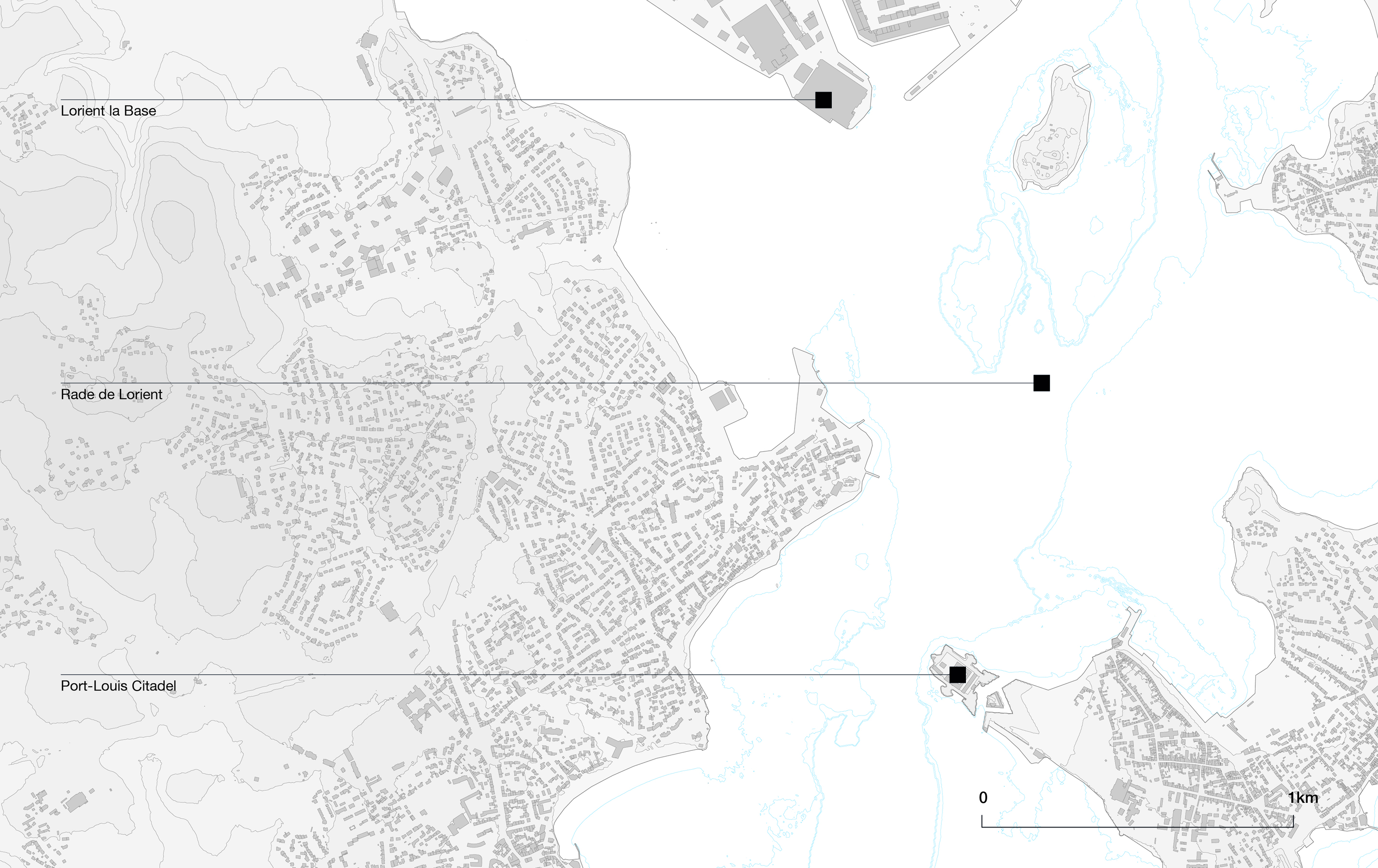
Encircled by gently sloping shores and tidal wetlands, the Rade de Lorient stretches from the confluence of the Blavet and Scorff rivers to the open waters of the Atlantic. Its sheltered depth and broad estuarine expanse create a natural harbour of exceptional ecological value and maritime potential. Recognised as a Natura 2000 site under the European Union Birds Directive, the Rade encompasses the marshes of Pen Mané, the Petite Mer de Gâvres, and the ponds of Kervran and Kerzine—zones that host large populations of migratory and nesting waterbirds. Managed by Lorient Agglomération, its conservation strategy combines biodiversity monitoring with the sustainable use of the estuarine landscape.
Over the centuries, the Rade de Lorient’s geographical features have supported a wide range of maritime functions. In the 17th century, its deep and sheltered waters made it the ideal location for the French East India Company, whose trading port and settlements anchored France’s early global networks. The harbour’s strategic position later attracted extensive military development, with successive fortifications, naval installations, and shipyards shaping both its landscape and its economy. From the 19th century onwards, and especially after World War II, Lorient evolved into one of France’s principal fishing ports, sustaining a thriving dockside culture subsequently rooted in collective memory and local identity. Although industrial fishing has since declined, this heritage remains visible in the Rade’s continued balance between professional, recreational, and ecological uses, reflecting the long interplay between human activity and the natural environment.
The transformation of the former submarine base into the Cité de la Voile Éric Tabarly exemplifies the creative rehabilitation of difficult heritage, converting a wartime structure into a lively centre for sailing, ocean racing, and maritime education. The complex offers exhibitions, interactive experiences, and guided tours that engage visitors with both technological innovation and environmental awareness. Through international races, local festivals, and community initiatives, the Rade de Lorient continues to connect nature, history, and creativity—standing as both a protected natural site and a living space of intangible maritime heritage.
Heritage type
Immaterial
Natural
Time period
17th century onwards
GPS coordinates
47.72839525584193, -3.3710995318317445
Inscription on the NEB Compass
The Rade de Lorient embodies the principles of the New European Bauhaus through sustainability, inclusion, and aesthetics. As a Natura 2000 site, its wetlands and sheltered waters illustrate a balance between biodiversity protection and human activity, supporting eco-conscious maritime practices such as low-carbon sailing events like the Défi Azimut. Guided boat tours, educational programmes, and cultural events connect residents and visitors to the maritime environment, fostering participation and social cohesion. Accessibility initiatives promote sailing experiences for both people with reduced mobility and the wider public, enabling engagement with the Rade from shore to sea. Visually, the coexistence of preserved natural landscapes, historical port structures, and contemporary sailing facilities creates a harmonious and dynamic aesthetic seascape. By uniting ecological innovation, community engagement, and coastal beauty, the Rade de Lorient stands as a model of NEB-inspired maritime heritage, demonstrating how natural and cultural assets can support sustainable, inclusive, and culturally enriching development.
References
— Hémery, F., Le Bail, Y. & Gélinaud, G. (2022). Site Natura 2000, Rade de Lorient — Suivi des oiseaux d’eau migrateurs, hivernants et nicheurs. Rapport final des saisons 2018 à 2022. Lorient Agglomeration / Natura 2020.
— Cérino, C. (2022). “Lorient et la mer: représentations, relations au patrimoine et développements muséographiques dans une ville portuaire de la reconstruction (1945-2021)”, Revue d’histoire maritime, no. 31-32, pp.121-146.
— Le Bouëdec, G. & Le Brigand, D. (2015). Lorient Keroman. Du port de pêche à la cité du poisson. Marines Nantes.
— Sokombe, K. et. al. (2024). Atlas de la rade de Lorient estuaire du Blavet & du Scorff. Lorient agglomération / Région Bretagne (http://www.radedelorient.atlas-rivieres.bzh/)

Layered maritime landscape combining ports, naval infrastructure and circulation routes within a semi-enclosed coastal system.
Yvan Zeda

Natural harbour formed by the confluence of the Blavet, Scorff and Ter rivers, creating a protected maritime basin connected to the Atlantic.
Bibliothèque Nationale de France
, Bibliothèque Nationale de France.")
Strategic roadstead structured by navigation channels and reefs, historically supporting commercial, military and fishing activities.
in Félix Lucas, Les Travaux publics de la France : Routes et ponts, chemins de fer, rivières et canaux, ports de mer, phares et balises (1883), Bibliothèque Nationale de France.
Encircled by gently sloping shores and tidal wetlands, the Rade de Lorient stretches from the confluence of the Blavet and Scorff rivers to the open waters of the Atlantic. Its sheltered depth and broad estuarine expanse create a natural harbour of exceptional ecological value and maritime potential. Recognised as a Natura 2000 site under the European Union Birds Directive, the Rade encompasses the marshes of Pen Mané, the Petite Mer de Gâvres, and the ponds of Kervran and Kerzine—zones that host large populations of migratory and nesting waterbirds. Managed by Lorient Agglomération, its conservation strategy combines biodiversity monitoring with the sustainable use of the estuarine landscape.
Over the centuries, the Rade de Lorient’s geographical features have supported a wide range of maritime functions. In the 17th century, its deep and sheltered waters made it the ideal location for the French East India Company, whose trading port and settlements anchored France’s early global networks. The harbour’s strategic position later attracted extensive military development, with successive fortifications, naval installations, and shipyards shaping both its landscape and its economy. From the 19th century onwards, and especially after World War II, Lorient evolved into one of France’s principal fishing ports, sustaining a thriving dockside culture subsequently rooted in collective memory and local identity. Although industrial fishing has since declined, this heritage remains visible in the Rade’s continued balance between professional, recreational, and ecological uses, reflecting the long interplay between human activity and the natural environment.
The transformation of the former submarine base into the Cité de la Voile Éric Tabarly exemplifies the creative rehabilitation of difficult heritage, converting a wartime structure into a lively centre for sailing, ocean racing, and maritime education. The complex offers exhibitions, interactive experiences, and guided tours that engage visitors with both technological innovation and environmental awareness. Through international races, local festivals, and community initiatives, the Rade de Lorient continues to connect nature, history, and creativity—standing as both a protected natural site and a living space of intangible maritime heritage.
Heritage type
Immaterial
Natural
Time period
17th century onwards
GPS coordinates
47.72839525584193, -3.3710995318317445
Inscription on the NEB Compass
The Rade de Lorient embodies the principles of the New European Bauhaus through sustainability, inclusion, and aesthetics. As a Natura 2000 site, its wetlands and sheltered waters illustrate a balance between biodiversity protection and human activity, supporting eco-conscious maritime practices such as low-carbon sailing events like the Défi Azimut. Guided boat tours, educational programmes, and cultural events connect residents and visitors to the maritime environment, fostering participation and social cohesion. Accessibility initiatives promote sailing experiences for both people with reduced mobility and the wider public, enabling engagement with the Rade from shore to sea. Visually, the coexistence of preserved natural landscapes, historical port structures, and contemporary sailing facilities creates a harmonious and dynamic aesthetic seascape. By uniting ecological innovation, community engagement, and coastal beauty, the Rade de Lorient stands as a model of NEB-inspired maritime heritage, demonstrating how natural and cultural assets can support sustainable, inclusive, and culturally enriching development.
References
— Hémery, F., Le Bail, Y. & Gélinaud, G. (2022). Site Natura 2000, Rade de Lorient — Suivi des oiseaux d’eau migrateurs, hivernants et nicheurs. Rapport final des saisons 2018 à 2022. Lorient Agglomeration / Natura 2020.
— Cérino, C. (2022). “Lorient et la mer: représentations, relations au patrimoine et développements muséographiques dans une ville portuaire de la reconstruction (1945-2021)”, Revue d’histoire maritime, no. 31-32, pp.121-146.
— Le Bouëdec, G. & Le Brigand, D. (2015). Lorient Keroman. Du port de pêche à la cité du poisson. Marines Nantes.
— Sokombe, K. et. al. (2024). Atlas de la rade de Lorient estuaire du Blavet & du Scorff. Lorient agglomération / Région Bretagne (http://www.radedelorient.atlas-rivieres.bzh/)